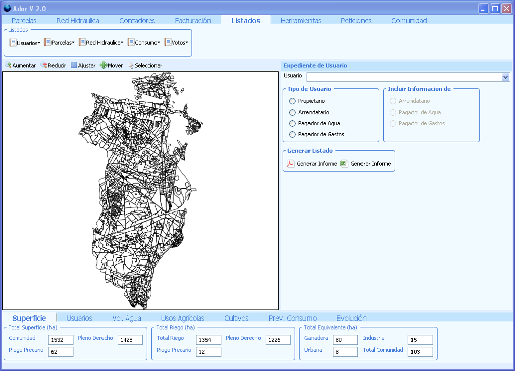
Software: ADOR-GESTIÓN, a managing aid for water users associations
This program is in daily use in water users associations adding up to some two hundred thousand hectares of irrigated land. Ador-Gestión manages water users, uses, crops, infrastructure, water used and billing, among other aspects. The software, with intellectual property deposits in favor of the CSIC, the SARGA company of the Government of Aragón and the General Water Users Association Riegos of Alto Aragón, is being developed by the “Ador Developers Association” to extend its use to other irrigable areas. In addition to the Ador-Gestión software, the auxiliary DibujaGrafo software was developed.
More information on Ador-Gestión.
More information on DibujaGrafo.
Educational tool: SANDBOX, create and modify landscapes as you wish
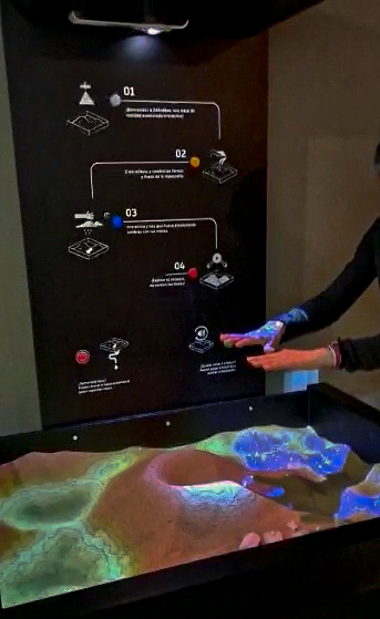
“Sandbox: create and modify landscapes as you wish”, is an interactive exhibition of augmented reality (Augmented Reality Sandbox) to simulate the modeling of the relief and surface water flows. It allows the public to interact directly with the arena. Geographical, geological and hydrological concepts, the meaning of contour lines, river basins, etc., become a visible reality in the sandbox in an interactive way. Rain can be triggered to check the directions of water flow through the terrain. Sandbox can be currently visited in the permanent exhibition of the Museum of Natural Sciences of the University of Zaragoza.
Software: GINASAT, management of satellite information with GIS
The software is integrated in ArcGIS®. It automates the extraction of satellite information from Landsat images downloaded from the United States Geological Survey (USGS) Earth Explorer server. GINASAT v1.0 facilitates the processing of time series of satellite images to systematically obtain territorial information with a view to managing spaces of interest. It allows the monitoring of physical variables related to land cover and vegetation, considerably reducing the time spent on data processing. The Software was registered in 2015.
Software: SLICES, capas sintéticas del suelo
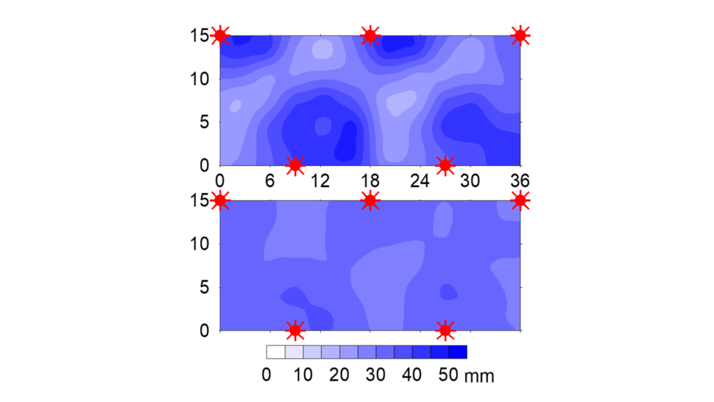
SLICES is a tool that automates the treatment of soil profile data sampled at any depth and facilitates the calculation and graphical representation of synthetic layers of soil features or calculates a single value for the desired soil depth. SLICES calculates synthetic values of physical or chemical characteristics (of additive magnitudes) of the soil profile by weighting the value of the characteristic of the sample by the thickness of the soil represented by said sample. Synthetic values are obtained for successive layers (“synthetic layers”) of homogeneous thickness to be chosen by the user. Synthetic soil layers simplify, but often smooth, values from horizons of different thicknesses. This facilitates the comparison between different profiles of the depth distribution of soil characteristics. Synthetic layer values can be plotted on standard Piper, Schoeller-Berkaloff, and Durov hydrochemical diagrams.
Software: RIDECO, scheduling regulated deficit irrigation
RIDECO is an application aimed at scheduling regulated deficit irrigation in stone fruit trees. The application has a user interface that allows automatic downloading of meteorological data from the network of agrometeorological stations of the Ministry of Agriculture, Fisheries and Food (SIAR network) and uses the methodology of cumulative thermal integral to identify the duration of the phases of fruit growth and crop development. The software allows for each weather station to calculate the weekly irrigation needs in standard conditions, under regulated deficit irrigation conditions and even in water restricted conditions. These calculations can be made for an average year (with historical data) or for the current year (in real time).
Software: ADOR-ASPERSIÓN, simulation of solid-set sprinkler irrigation
Ador-Aspersión is a software for the simulation of solid-set sprinkler irrigation. The program allows the simulation of irrigation quality (distribution uniformity and irrigation efficiency) under different technical and meteorological conditions. It allows to simulate different sprinkler models, equipped with different nozzle sizes, working at pressures between 200 to 400 kPa and under different sprinkler settings. In addition, it incorporates the effect of meteorological variables such as wind and relative humidity, both in the spatial distribution of water and in losses due to drift and evaporation from sprinkler irrigation.
More information on Ador-Aspersión.
Software: SURCOS, simulating irrigation and fertigation in furrow networks
SURCOS is a software for the simulation of irrigation and fertigation in isolated furrows and in furrow networks. It incorporates a one-dimensional hydrodynamic model with second-order solute transport approximation together with a confluence model for surface flow. This model is coupled with the Kostiakov-Lewis infiltration model adapted to furrows. The model was described in Burguete et al. (2009a) and practical applications of the model can be seen in Burguete et al. (2009b). From the computer point of view, the program was described in Burguete et al. (2014). It has a simple and interactive graphical interface and presents graphs and a summary of the results.
Software: SWOCS, analyzing transient flows in open channels
SWOCS is a software to analyze the accuracy, computational speed, and algorithmic complexity of different resolution models of one-dimensional transient flows in channels or furrows. The complete hydrodynamic model and several simplified models have been implemented in the program: zero-convection, zero-inertia and kinematic wave. In all of them, different schemes have been used: implicit first order upwind, explicit first order upwind and Lax-Friedrichs. In addition, the second order TVD method has also been implemented in the complete model.
Software: Ador-Control, automatic control of on-farm irrigation
Ador-Control is a software aiming at controlling sprinkler irrigation on commercial plots. The program generates and executes irrigation schedules adapted to the crop water requirements and the weather, with special emphasis on the effect of the wind on uniformity, the potential irrigation efficiency and wind drift and evaporation losses. Irrigation schedules are produced using simulation models. AdorControl is made up of auxiliary libraries that provide plot irrigation simulation (AsperLib), crop simulation models (CWLib), meteorological database management (MeteoLib) and soil type property management (SueLib). Schedules can be executed in real time.
More information on Ador-Control.
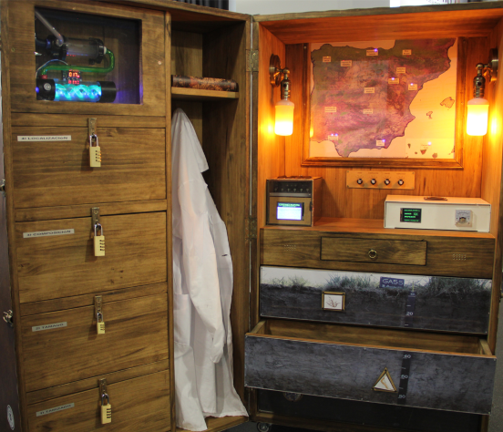
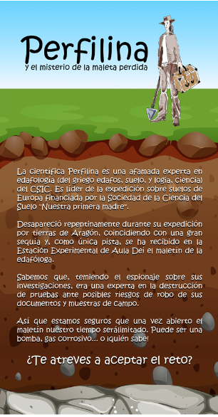
Educational tool: PERFILINA, a scientific escape room
The scientific escape room ‘Perfilina and the mystery of the lost soil scientist’ is an informative proposal that brings soil science closer to the youngest in an entertaining and interactive way. The scientist Perfilina is a famous expert in edaphology (from the Greek edaphos, soil, and logia, science) of CSIC. Perfilina is a true genius and innovator in the study of soil profiles. She is an entrepreneur and a tireless traveler, she is also the leader of the expedition on soils in Europe financed by the Society of Soil Sciences ‘NUESTRA PRIMERA MADRE’ (because that was how Don Quixote referred to the soil). Perfilina suddenly disappeared during her expedition through Spanish lands, in coincidence with a terrible drought, and the only clue received at the Aula Dei Experimental Station in Zaragoza was the soil scientist’s briefcase. We know that she was a great scientist and researcher, and that fearing espionage on her research, she was an expert in the destruction of evidence in the face of possible risks of theft of her documents and field samples. That is why we are sure that once the briefcase is opened, our time will be limited. It could be from a bomb, corrosive gas, or… who knows! Do you dare to accept the challenge?
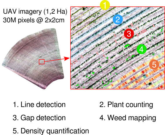
Software: LINEGADE-Crop, information on crop emergence failure
LINEGADE-Crop (LINEs & Gap DEtection in Crop plot) has been designed with the aim of obtaining both quantitative and cartographic information on emergence failure in a crop plot. It is a computer tool for the detection of discontinuities in linear elements adapted to crop plots. The software has been designed for the location of emergence failures from a raster image (RGB, multispectral, neochannels, etc.) in which the crop rows can be seen. It provides the location of crop rows, location of sprouting failures, quantitative information on the number of plants and sprouting failures, and a vegetation density map. The tool is completed with an application for the detection of weeds present between the crop rows, also providing a map of weeds. All the information that is generated can be visualized and spatially analyzed with a geographic information system, such as the free software QGIS. The authors are Latorre B, Casterad M.A. and López-Marín C.